FARM AND RURAL DRONE PHOTOGRAPHY IN CENTRAL QUEENSLAND
Aerial photos of stations, studs, farm stays and agritourism properties in Central Queensland. $199 for a photo set, $399 with a 30 to 60 second video.
A real aerial
A BOUNDARY MARKED FROM ABOVE.
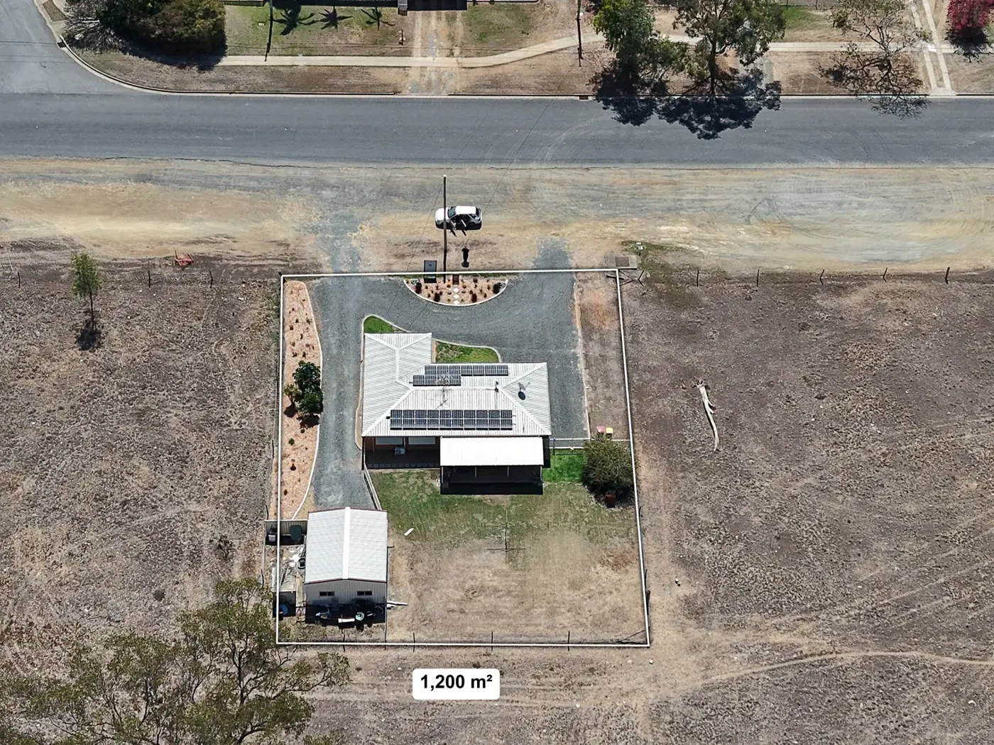
A top-down drone photo of a 1,200 m² block at Gracemere, shot on 7 October 2026 for a real estate listing, with the boundary marked on it. The same marking works on a paddock or a farm stay. Lines drawn on a photo are a guide, not a survey.
THE PROBLEM
WHY A FARM IS HARD TO PHOTOGRAPH FROM THE GROUND.
A fence line, a dam, the yards and the homestead cannot fit in one frame from the ground, so a website or a sale ad ends up with a few shots of the front gate. A drone gets above all of it and shows how the property fits together.
WHY IT MATTERS
WHAT AN AERIAL SHOWS A VISITOR OR A BUYER.
- 01The layout and scale: paddocks, dams, sheds, the house and the access road in one photo.
- 02For farm stays and agritourism, guests can see the setting before they book.
- 03For studs and sale days, buyers can see the yards and facilities.
- 04Boundaries and key features can be marked on a photo to help explain the property.
- 05A short video and a vertical reel give you something to post between busy seasons.
WHAT YOU GET
WHAT'S INCLUDED.
Who it's for
WHO BOOKS RURAL AERIALS.
- Stations and grazing properties
- Cattle and horse studs
- Farm stays and cabins
- Agritourism and rural venues
- Rural suppliers and sale yards
Where I work
AROUND ROCKY AND OUT TO THE STATIONS.
Properties around Rockhampton, Gracemere, Yeppoon and Emu Park have no travel charge. Stations and farms further out are quoted when you send me the nearest town.
Emerald, Moranbah, Mackay, Biloela and other towns more than two hours from Rockhampton work differently. I book trips when a few jobs are lined up in your area, and the travel cost is split across every job on that day. Tell me your town and what you need, and I will let you know when a trip is planned there.
The rules
WHAT THE DRONE CAN AND CAN'T DO.
I am a CASA accredited operator with a registered drone, and I fly under CASA's rules for small drones. Open rural land is one of the easiest places for me to fly, because there are usually no houses or crowds underneath.
- It flies in daylight only, and I keep it in sight the whole time.
- It stays under 120 metres.
- It does not fly over houses, streets or crowds.
- It keeps 30 metres from anyone who is not part of the job, so staff and customers need to stand clear while it is in the air.
- Neighbouring homesteads and public roads still count, so some boundary angles may not be possible.
- Drones can spook stock. Tell me where the animals are and we plan the flight around them.
- Parts of Rockhampton and Gracemere are close to the airport. I check the airspace for every address before I quote it, and if the answer is no I tell you straight away.
- Wind and rain move the job to another day.
HOW IT WORKS
THE PROCESS.
TELL ME ABOUT THE PROPERTY
Send the address or the nearest town and what the photos are for. I check the airspace and the access.
AGREE THE SHOTS
We settle the views you want, whether it is the photo set or the set with video, and the price. I pick a day with good weather.
THE VISIT
I fly the property, usually inside an hour once I am there. You tell me where the stock is and which areas to keep clear.
EDIT AND DELIVERY
I choose the best shots, edit them, add boundary lines if you asked, cut the video if you booked it, and send a download link.
PER JOB
FROM $199 A JOB
One-off jobs, priced before I fly. There is no travel charge for properties around Rockhampton, Gracemere, Yeppoon and Emu Park. Properties further out are quoted, with the travel split across the jobs on the day.
- Rural photo set$19910 to 15 edited aerial stills of your property, colour corrected and sized for web and print.
- Rural photos and video$399The photo set plus an edited 30 to 60 second video and a vertical reel for Facebook and Instagram.
WHY WORK WITH ME
WHAT MAKES THIS DIFFERENT.
- CASA accredited operator with a registered drone
- Photos and video from the same flight
- Rockhampton based, so properties around the Capricorn Coast and Gracemere have no travel charge
- A fixed price agreed before the visit
FREQUENTLY ASKED
QUESTIONS I GET ASKED.
How much does farm drone photography cost?
A photo set is $199 for 10 to 15 edited aerial stills of your property. Photos and video is $399: the same stills plus an edited 30 to 60 second video and a vertical reel. There is no travel charge around Rockhampton, Gracemere, Yeppoon and Emu Park.
Will the drone upset my stock?
It can. Drones can spook cattle and horses, so tell me where the animals are and we plan the flight around them. We can also shoot a paddock after the stock has been moved.
Can you mark my boundary on a photo?
Yes, where you want it, like the boundary on the Gracemere photo above. It is a guide drawn on a photo, not a survey, so use a registered surveyor if you need exact boundaries.
How far out do you go?
Properties around Rockhampton, Gracemere, Yeppoon and Emu Park are an easy drive. For stations and farms further out, I book trips when a few jobs are lined up in your area, and the travel cost is split across the jobs on the day. Tell me your nearest town and I will let you know when a trip is planned.
Can you fly near the airport or over a road?
I check the airspace for every address, and parts of Rockhampton and Gracemere are close to the airport. I cannot fly over houses, streets or crowds, so a public road through the property may limit some angles.
Do you fly in the wind or rain?
No. Wind and rain move the job to another day, and I fly in daylight only.
READY TO GET STARTED?
TELL ME ABOUT THE PROPERTY.
Text or call with the address or the nearest town, and what the photos are for. I check the airspace and tell you what is possible, then give you a price before anything is booked.
OTHER SERVICES
MORE WAYS I CAN HELP.
AERIAL DRONE PHOTOGRAPHY FOR BUSINESS
Drone photos of your yard, workshop, farm, venue or depot. $199 for a set of edited stills, $399 with a 30 to 60 second video.
REAL ESTATE PHOTOGRAPHY, DRONE & FLOOR PLANS
Real estate photography, drone photos, floor plans and listing films for agents in Rockhampton, Yeppoon, Gladstone and across Central Queensland. Drone photos $199, drone and inside photos from $499, full listing launch from $699, rental photos $149. First listing free for Rockhampton, Gracemere and Yeppoon agencies.
DRONE PHOTOGRAPHY FOR MINING SERVICES
Aerial photos of your yard, fleet and workshop for mining service businesses. Off-lease only: no mine sites and no survey work. $199 for photos, $399 with video.